Ypres
Introduction
The old village of Ypres has been destroyed during the first world war in 3 major fights:
- 1st Ypres (October - November 1914), creating the salient of Ypres.
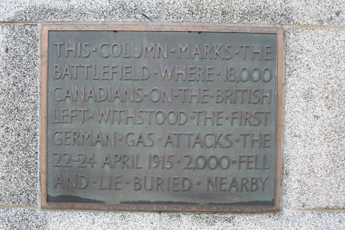
- 2nd Ypres (22 April - 24 May 1915), the first gas attack St. Julien (Sint Juliaan).
- 3rd Ypres (31 July - 10 Novemver 1917), also known as Passchendaele (Passendale).
Well known poem line by Siegfried Sassoon: I died in hell, (They called it Passchendaele). - 4th Ypres (09 April - 29 April 1918), also known as The battle of Lys.
German forces attacked Ypres with a large offensive with the intentions to take back Ypres. - 5th Ypres (28 September - 11 November 1918), less known, but lasted until the end of the first world-war.
The allies taken advantage of the low German moral.
Map 1914-1918
| 2 June 1917
The main artillery action is taking place to the south and southeast of the city, in the area between Kemmel and St Eloi.
Source: https://www.facebook.com/PhilipStevensGreatWar/?hc_ref=PAGES_TIMELINE&fref=nf# |

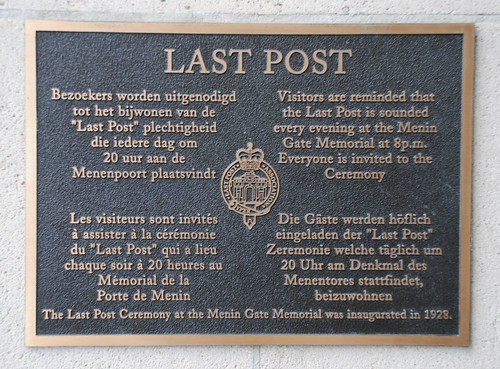
Last Post
Since 1928 every day at 20:00 the Last Post is sounded by the Fire Brigade at Ypres Memin Gate. This is really a very special and memorable part of anyone's visit to Ypres.
|
In total the following losses/Casualties (Killed, Wounded and Missing) in this area only:
Every year until now:
|
| |||||||||||||||||||||
| Ypres, Menim Gate Memorial, the last post by the fire brigade. |
First battle
| On October 3, 1914 the Germans occupying Ypres. A day later German advance towards the Coast occupying Lens, Comines, Poperinghe, Bailleul and more.
On October 13 the allies occupying Ypres trying to attempt an offensive. On October 16 the battle of the Yser. The Yser held by the Belgians against the Germans: struggle from Lombartzyde to Keyem. Followed by the first battle of Ypres October 19 (Sir Henry Rawlinson unable to occupy Menin). On the right is a picture of the most dangerous places in Belgium, Hellfire Corner, located on the East of Ypres.
|
 |
Second battle
| Canadian monument for the first Gas attack at St. Juliaan Belgium (22 april 1915) .
A combination of French territorials and Algerian troops held the line to the left, with the British and Canadians tending the centre and line to their right. During the morning of 22 April the Germans poured a heavy bombardment around Ypres, but the line fell silent as the afternoon grew. Towards evening, at around 5 pm, the bombardment began afresh - except that sentries posted among the French and Algerian troops noticed a curious yellow-green cloud drifting slowly towards their line. Puzzled but suspicious the French suspected that the cloud masked an advance by German infantry and ordered their men to 'stand to' - that is, to mount the trench fire step in readiness for probable attack. The cloud did not mask an infantry attack however; at least, not yet. It signalled in fact the first use of chlorine gas on the battlefield. Ironically its use ought not to have been a surprise to the Allied troops, for captured German soldiers had revealed the imminent use of gas on the Western Front. Their warnings were not passed on however. The effects of chlorine gas were severe. Within seconds of inhaling its vapour it destroyed the victim's respiratory organs, bringing on choking attacks. Panic-stricken the French and Algerian troops fled in disorder, creating a four-mile gap in the Allied line. Had the Germans been prepared for this eventuality they could potentially have effected a decisive breakthrough. However the results of their experiment caused as much surprise to the German high command as confusion among their opponents. |
Commemorative plaque on the memorial of the mourning soldier in Sint Juliaan. |
Gas Attack
|
“Finally, we decided to release the gas. The weatherman was right. It was a beautiful day, the sun was shining. Where there was grass, it was blazing green. We should have been going on a picnic, not doing what we were going to do. We sent the (German) infantry back and opened the (gas)valves with the strings. About supper time, the gas started toward the French; everything was stone quiet. We all wondered what was going to happen. As this great cloud of green-grey gas was forming in front of us, we suddenly heard the French yelling. In less than a minute they started with the most rifle and machine gun fire that I had ever heard. Every field artillery gun, every machine gun, every rifle that the French had, must have been firing. I had never heard such a noise. The hail of bullets going over our heads was unbelievable, but it was not stopping the gas. The wind kept moving the gas towards the French lines. We heard the cows bawling, and the horses screaming. The French kept on shooting. They couldn’t possibly see what they were shooting at. In about 15 minutes the gunfire started to quit. After a half hour, only occasional shots. Then everything was quiet again. In a while, it had cleared and we walked past the empty gas bottles. What we saw was total death. Nothing was alive. All of the animals had come out of their holes to die. Dead rabbits, moles, and rats and mice were everywhere. The smell of the gas was still in the air. It hung on the few bushes which were left. When we got to the French lines the trenches were empty but in a half mile, the bodies of French soldiers were everywhere. It was unbelievable. Then we saw there were some English. You could see where men had clawed at their faces, and throats, trying to get a breath. Some had shot themselves. The horses, still in the stables, cows, chickens, everything, all were dead. Everything, even the insects were dead."
|

Third battle (Passendale)
The battles in the third Passendal are:
The Third Battle of Ypres was, like its predecessors, a costly exercise. The British Expeditionary Force (BEF) incurred some 310,000 casualties, with a similar, lower, number of German casualties: 260,000.
The salient had been re-widened by several kilometres. In 1918 the BEF withdrew the salient, returning all the conquered land of 1917, making all the losses and sufferings for nothing!
|
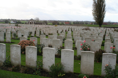
Passendale (Passchendaele), Tyne Cot, I died in hell, they called it Passchendaele. |
Overview Map
The following map contains a few locations of the South-East of Ypres. See the legend to find alle the places.
Map contains information based on a KML [7] file which can be downloaded and used in Google Earth [8].
Not all points are visible. Use the scrolling of the map to find more locations.
| Map | Legend |
|---|---|
| <googlemap lat="50.834848" lon="2.945556" zoom="13" controls="small" width="900" height="900">
http://www.harmfrielink.nl/KML/Ypres.kml </googlemap> |
A: Menim Gate B: Hellfire Corner C: Hill 62: Canadian Memorial D: Trenches hill 62 E: Museum Hill 62 F: Sanctuary Woods G: Hill 60 H: Hooge Crater I: Buttes Cemetery J: Polygon Wood Cemetery K: Bellewaerde
|
See also
- WW1 Locations, Locations on Internet maps. Contains maps and links to other maps including one this page.
- Tyne Cot Cemetery, the largest British cemetery outside Great Britain.
- List of Bloodiest Battles, The list does not contain Ypres.
Extenal links
- Graven in de Grootte oorlog, Uit de Standaard.
- Passendaele,
- youTube, Hellfire Corner Now and Then movie.
- First World War, Ypres 3 (Passchendaele).
Books
- De derde slag bij Ieper 1917, Koen Koch 2007, Ambo Anthos, ISBN 978-90-263-20781